Search
Recent comments
- booed....
2 hours 56 min ago - perspective persia....
5 hours 37 min ago - yangibana.....
5 hours 49 min ago - diverse....
5 hours 56 min ago - дети.....
6 hours 26 min ago - interuptor.....
8 hours 30 min ago - meanwhile:
8 hours 49 min ago - IMEC...
8 hours 52 min ago - media politics....
9 hours 50 min ago - good deals...
10 hours 22 min ago
Democracy Links
Member's Off-site Blogs
the deluge...

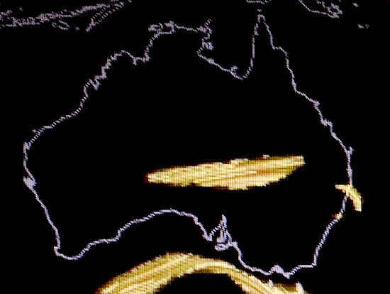
Here's the latest shot at 11 am, 08/03/2022, of the Jet Stream over Australia.
You don't have to be an expert to know it's pathetic. We cannot speculate really if the pissy Jet Stream of the last few days is the cause or is the effect of the silly weather we are having here in Sydney. My guess would be that because the Jet Stream is so weak, it cannot push away the "normal" alternate of high and low pressure system over the continent, usually changing the system every three days.
So why is the Jet Stream so weak? The La Niña is responsible we would suggest. But I guess the ocean and air temperatures are quite higher than during previous La Niña events... This should hold off the dew point, but the atmosphere is holding far more moisture than before, due to global warming — and the water has nowhere to go but down in buckets, in cats and dogs or as the French would say: like pissing cows... The Germans say: Das Hundewetter.
Looking at the evolving Jet Stream, the moist air mass was dragged back once more over the coast by the weakling JS, overnight...
----------------------
Thousands of people in Sydney's south-west have been ordered to leave their homes as the Georges River sparks flooding in the area.
An east coast low is causing significant rainfall over Greater Sydney and its surrounds, and authorities have warned it is expected to continue for an extended period.
Follow the latest updates.
Read more:
https://www.abc.net.au/news/2022-03-08/sydney-rain-blog-flooding-sparks-evacuation-orders/100890524
FREE JULIAN ASSANGE NOW !!!!!!!!!!!!!!!!!!!!
- By Gus Leonisky at 8 Mar 2022 - 11:03am
- Gus Leonisky's blog
- Login or register to post comments
yesterday's deluge
Yesterday's Jet Stream about the same time as the one above (today)...
Read from top.
FREE JULIAN ASSANGE NOW !!!!!!!!!!!!!!!!!!!!!
jet streams on 9 march 2022...
Draw your own conclusions...
FREE JULIAN ASSANGE NOW.
jet streams…...
You wouldn’t know it from the torrential rains that have inundated large parts of New South Wales and Queensland this year, but average late-autumn rainfall over southeast Australia has declined significantly since the 1990s.
Less rain in these areas is an expected consequence of global warming. In both the northern and southern hemispheres, the paths of the weather systems that bring rain in the middle latitudes have been moving away from the equator and towards the poles.
Read more: Australia's dry June is a sign of what's to come
We studied in detail the drop in rainfall during April and May in southeast Australia, and found it is just one consequence of far-reaching changes in the behaviour of high-altitude winds over Australia.
Jet streamsThese high-altitude winds are called jet streams: narrow bands of rapidly flowing air that typically occur at altitudes around the cruising height of commercial passenger aircraft. In April and May, the westerly jet stream over southeast Australia normally splits into a northern branch (called the subtropical jet) and a southern branch (called the polar-front jet).
READ MORE:
https://theconversation.com/changes-in-the-jet-stream-are-steering-autumn-rain-away-from-southeast-australia-184649?utm_medium=email&utm_campaign=Latest
READ FROM TOP: We've been on the case for a while......
FREE JULIAN ASSANGE NOW. KEEPING ASSANGE IN PRISON IS EVIL.........